This guest blog post was written by Michael Rodgers, Chief Executive Officer of Critical Response Group
Understanding Critical Incident Mapping
Critical Incident Mapping, is a pivotal tool in enhancing the safety and security of publicly accessible buildings such as schools, hospitals, and shopping centers. The technique which was originally derived from the US Military special operations community has evolved into a crucial component for emergency response planning across the nation. The goal is to establish a common operating picture and a unified understanding of unfamiliar locations during emergencies.
Critical Incident Mapping is a growing nationwide movement and has been implemented across thousands of schools, hospitals, airports, and critical infrastructure buildings nationwide. So far, more than seven states, recognizing its value, have passed unanimous bipartisan legislation to utilize this tool for schools, making it a standard component in all emergency response protocols.
Why is Critical Incident Mapping Important?
Too often in a crisis situation, emergency response teams find themselves unprepared due to a lack of reliable location data to coordinate personnel. What makes these situations more challenging is that internal security, police, EMS, fire departments and other first responders may be operating on different location information. This can lead to miscommunication during emergencies. Spending critical minutes aligning location information can be disastrous, especially when compounded with the stress of the emergency. Traditional facility blueprints and building schematics are often inaccurate, unlabeled, and incompatible with the technical platforms used by public safety units. Critical Incident Mapping addresses these challenges by providing accurate, clear, and easily communicable maps that are accessible through any preexisting software platform or smart device.
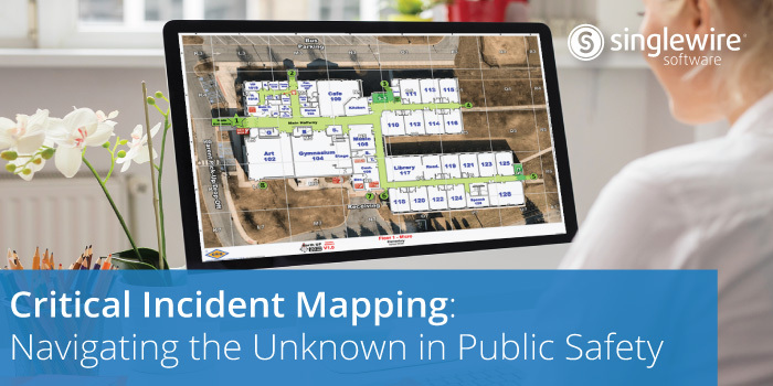
It’s important to note though, critical incident maps are more than just digitized floor plans; they are comprehensive visual communication and collaboration tools designed to be usable during stressful situations. They combine valuable information such as a gridded reference system, high-resolution imagery, properly labeled floor plans, and critical features within a building and its surrounding areas to create a communication tool that is indispensable in a crisis.
Features of Critical Incident Maps
Robust critical incident maps include several key features that make them vital tools during a crisis. These include:
- Grid & Template: For spatial understanding and communication.
- Key Landmarks & Critical Features: Identification of AED, Gas, etc.
- Site-Specific Labels and Nomenclature: For clear and precise communication.
- Highlighted Hallways, Stairwells, Doors, Exits: For quick navigation.
- GeoRelevant Integrated Floor Plans and Aerial Imagery: For accuracy and context.
- Sharable & Integrated: Easily shared among disparate teams and integrated into existing tools.
Critical Incident Mapping is a revolutionary tool that has transformed emergency response strategies, providing a unified, clear, and accurate understanding of unfamiliar locations. By developing a common language and understanding, organizations can improve situational awareness and take a key step forward in making their communities safer and more resilient.
CRG Maps and InformaCast Mass Notification
Critical Response Group® (CRG®), the nation’s leader in Critical Incident Mapping data, believes that a common language fosters better collaboration. Through Critical Incident Mapping, CRG ensures that all emergency response personnel operate from a unified understanding of a location, including its specific nomenclature and exact features. This common operating picture is invaluable in saving critical moments during emergencies, which can ultimately save lives.
Through a partnership with Singlewire Software, organizations can now access CRG maps within InformaCast to see where certain notifications have been initiated from within a building. Organizations will be able to define buildings, floors, and rooms with CRG Collaborative Response Graphics® that have been uploaded into InformaCast. Those details will be tied to the scenarios an organization creates. When a scenario is initiated from the InformaCast app, a Cisco IP phone, or Microsoft Teams, the user will be able to add location details to their message. Recipients will receive the notification along with a map that has a highlighted area indicating the sender’s location. This helps provide critical information to responders who can ascertain where the person is and send assistance.
It’s not too late to look into mapping your location—across the country, schools and other public institutions often use grants or other funding mechanisms to cover or offset the cost of mapping their campuses, ensuring that these maps are kept on file and integrated into the platforms used by public safety agencies. You can find more information on specific critical incident grant funding in your state at www.crgplans.com/funding.
Visit the Critical Response Group website for more information about the benefits of critical incident mapping, and learn more about the partnership with CRG and Singlewire software here.